


Share Data Between Drawings and Applications > Work with Data in Other
Formats > Attach Raster Image Files > Modify Raster Images and
Image Boundaries >
Clip Raster Images |
|
Clip Raster Images |
|
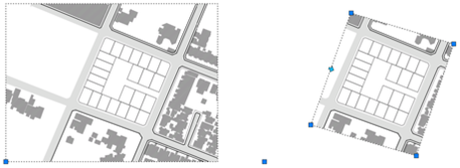
You can clip and display specific portions of a raster image in a drawing with a clipping boundary.
With a clipping boundary, only the parts of the image that you want visible are displayed. You can define the part of an image that you want to display and plot by clipping the image with IMAGECLIP. The clipping boundary can be a polyline, rectangle, or a polygon with vertices within the boundaries of the image. You can change the boundary of a clipped image.You can also delete the clipped boundary of an image. When you delete a clipping boundary, the original image is displayed.
You can invert the area to be hidden, inside or outside the clipping boundary. With grips located at the midpoint on the first edge of the clipping boundary, you can invert the display of the clipped reference inside or outside the boundary.
With IMAGEFRAME system variable, you can control the visibility of the clipping boundary.
 Expand All
 Collapse All


